Tag Archives: Transportation

Greater Toronto Area transit map

Many years ago, when Google first released Google Maps and revolutionized online mapping from the stagnant MapQuest era, I put together a few quick demos showing the Vancouver and Toronto transit maps. I’ve made a few updates over the years since then, but not much more.  The Vancouver one is still quite popular – more popular than TransLink’s own map, to be honest – but other web gurus made better Toronto maps, such as the excellent one by Ian Stevens.
I’ve noticed that Google has revamped the mapping APIs and is preparing to eliminate version 2.0. The whole treatment of online mapping is changing rapidly, as the mobile market takes off. I was thinking of just scrapping the Toronto map since it’s not well-used – but then I thought a little further. What if I could make a proper map of the Greater Toronto Area?  Ian’s map doesn’t cover that – in fact, since there isn’t even a good print product covering the full area. Perhaps I could make something useful for the “regional traveller” using GO, and also help mobile users who have trouble with Ian’s site.
I set to work, borrowing liberally from others. It’s a patchwork by nature, since each agency has its own colour and line conventions, but hopefully still useful. When Ian made his map, taking a bitmap image and turning it into tiles was a bleeding-edge endeavour and required painstaking effort – but the tools have improved a lot. Even still, a bitmap this size (35,000 pixels square) takes some horsepower. I didn’t have the energy to do everything Ian did (like removing the background); his map will still probably work better for most TTC riders. I also couldn’t figure out what map projection Oakville Transit used, and couldn’t get it to line up nicely with the other data.
I’ll probably do a few more revisions on this in the next few months – an adjustable opacity slider would be nice, a legend for each operator, and higher zoom levels. But I thought I’d release a beta version and see if anyone likes it, and see how expensive the bandwidth is.
Version 3 of my map is now up (and version 2 is still around for anyone who wants it). New in this version:

  • Local transit operator maps
  • More mobile friendly: full-screen view by default, location-aware (uses GPS to detect your current location, if available)
  • May seem slower, unless you have a new browser, like Google Chrome or Firefox 4
  • Graphics updates: labels cleaner, interchange stations cleaner, labels always visible instead of showing on hover (for touchscreen users)
  • Search tries to find a transit station first, otherwise tries other non-transit locations
  • No legend… yet
  • Added “Get directions to here” link to each station
  • API version 3
  • Fixes: added Lincolnville station, fixed broken links

Bryant and Road Rage


The judicial verdict is in on the sensational case of Michael Bryant. It sounds like a tragic case of a driver whose car’s stop/stall/roll action accidentally provoked an unstable bicycle courier, with tragic and ultimately fatal consequences. The driver appears to have behaved completely reasonably under the circumstances. The cyclist had a long history of aggressive confrontations and appears to have behaved in a threatening manner.
I take no issue with the facts of the case or the judgment. However, the incident has taken on large proportions in the media and the cycling community, and I find the official legal summary wanting in this regard.  The crisp, neutral judicial language gives the document the air of Truth and Justice, when in fact it only represents The Law.
The document answers the legal problem at hand, a judgment on dangerous driving, and therefore focuses entirely on what constitutes “reasonable driver behaviour” under the circumstances.  Lost in the context is what constitutes a reasonable cyclist’s reaction – and while the cyclist was not reasonable, an emotional reaction to having your rear wheel bumped is legitimate, and a subsequent furious reaction to being sent flying over the hood of the car is also fair.  Because the document is necessarily focused on the Law, all such points on the public debate of cyclist/driver perspectives and emotions are out of the picture.  Also lost in the discussion is any mention of the differences between car/car collisions from car/bike collisions – what may be a fender-bender in one context is an unnerving experience in the other, even if the vehicle doesn’t touch the cyclist’s skin, or if the vehicle is only going 13 km/h when it sends the cyclist flying over the hood.
The cycling community’s discontented reaction to the case stems from a desire for the driver world to “please understand our feelings!”  Unfortunately, this particular cyclist’s aggressiveness makes it an unlikely to elicit any soul-searching.  Note however the pattern: whether the cyclist is in the wrong (this case) or in the right (2008 story with a cyclist’s amputated leg), the cyclist will always be the one who gets injured or killed.
The morals: cyclists must hold their tempers, no matter the incident. And, there’s a profound lack of mutual understanding and respect still out there on the streets.

Winter cycling, Dutch style


Growing up in Toronto, I was a six-month cyclist and six-month pedestrian/transit rider. Since moving back a few years ago, I’ve been shifting to closer to ten months of cycling. I realized that I feel much better when I get that daily exercise and sunshine, and it’s considerably faster for getting around, chaining trips and running errands.
In the process, I’ve been trying to find the right bike for the job, and have just bought a pricy Dutch bike for the coming winter. My summer bike is out of the question; it’s a nice bike, and far too vulnerable to the winter salt, grit and filth.
Bicycle #1. I bought this road bike at the nadir of my student bank balance for $100. It’s as old as I am and a little too small. It handled reasonably well on the winter streets, the narrow tires were good at punching through the snow to find pavement, and the vintage handlebar-end shifters were easy to use with big mitts. The caliper brakes are the deal-breaker though: quite weak in wet conditions, and so tight around the wheel that I can’t have both fenders and knobbly tires. I rode it over the two winters of 2006-2008, when I lived in an apartment building. In that building, I could use the underground parking garage for cleaning and regular maintenance, and the bike thawed overnight in slightly-above-zero conditions. Rusting was a major problem: a new chain and rear cluster every spring, often cables as well, and a lot of surface oxidization wherever the paint had chipped off. Continue reading Winter cycling, Dutch style

Thesis: Synthesizing Agents and Relationships for Land Use / Transportation Modelling

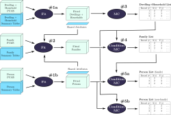
Figure from thesis
I finished my M.A.Sc. degree at the University of Toronto in August. In a past post, I discussed some of the coursework that made up the first year of the degree, but I haven’t really discussed the core research here before. I did win an award for some interim results presented at a local conference, but I wanted to hold back on too much public detail until some of my results were ready for publication. My paper submission to the Transportation Research Board was accepted this week, and my thesis will be formally published by the university next month, so there’s no need to hold back any further.
My research is a small piece of a larger research effort: trying to build integrated land use / transportation models that go beyond traditional transportation models. In classic four-stage models for forecasting travel demand, both the transportation network and the shape of the city (land use) is treated as an input to the model, and the travel patterns that would emerge from such a city are estimated. Typically, the goal is to see how changes to the transportation network would impact travel patterns – for example, building a new freeway or subway route. In reality, however, it is not valid to hold land use constant while changing the transportation network – land use reacts to the presence of transportation infrastructure.
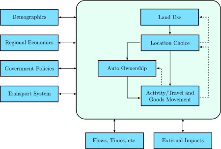
Models of this type have been under development for a long time, and my thesis is part of the ILUTE modelling effort at the University of Toronto. The figure below shows the ILUTE model structure, with land development, household location choice and automobile ownership as integral components of the model, not inputs to the model.
ILUTE model structure
My particular contribution is in the population synthesis part of the model, where I developed a faster and more capable method for synthesizing person, family, household and dwelling agents/objects; and a more robust method for creating the initial relationships between these agents.

  • Presentation: aimed at a fairly general audience (new civil engineering students), but perhaps a little cryptic without the narration.
    [HTML | Powerpoint]
  • Thesis: all of the gory details.
    [HTML | PDF]

Backcasting: From Climate to Transportation

This is a follow-up to my earlier post about Monbiot’s book on climate change. In that post, I stated that I was interested in long-term emissions targets because they will probably constrain transportation planning over the course of my career. Now that I’m looking at the issue more closely, I’ve found some relevant research: a great report from Robin Hickman and David Banister in the UK, Visioning and Backcasting for UK Transport Policy or VIBAT. (Reference courtesy of Todd Litman, VTPI.) It looks at the transport problem in the UK through a similar lens as Monbiot, but with considerably more rigour. For the record, VIBAT is not yet published in a peer-reviewed journal, although it has been presented at academic conferences. To date, I have only read the executive summary and skimmed the rest.
Domestic transportation in the UK emitted 39 MtC/year (megatonnes of carbon per year) in 1990, the Kyoto baseline. It rose slightly to 41 MtC/year by 2000, and is projected to rise to 52 MtC/year by 2030 in a “business-as-usual” scenario. A recent Department for Transport white paper suggested new policies for the UK, and projected that the 2030 level would be 38 MtC/year if those policies were adopted, a very small reduction from 1990 levels.
Hickman and Banister took a more dramatic approach. They chose a target of 60% reduction in domestic UK transportation emissions by 2030 from the standard 1990 baseline, aiming for a 15 MtC/year emissions level. This is not Monbiot’s target of a 90% cut by 2030, but it’s still an ambitious choice, somewhat more aggressive than the official UK goal of 60% by 2050.
In the early framing of the paper, the problems of air travel are abundantly clear: UK international air emissions are currently 8 MtC, and might be projected to rise to 20 MtC by 2030. I can’t imagine a scenario where it would be politically acceptable for air travel to be given a bigger slice of emissions than all domestic transportation. As the authors state, “Reducing carbon emissions from international air travel should be a priority for research and action.” In the report, they focus on domestic emissions alone, and leave air travel and international shipping outside their scope.
The authors came up with two scenarios for the policy climate in 2030.
Continue reading Backcasting: From Climate to Transportation

IPCC and Land Use

Mike passed me a recent report from the Intergovernmental Panel on Climate Change (IPCC) Working Group III (Mitigation of Climate Change). The IPCC is quite famous for its reports summarising the scientific consensus on climate science, so I was curious to see what the process and results of their follow-up reports looked like. I only read the transport chapter, since it’s the part I understand.
Overall, it’s a decent summary of current understanding of transportation trends, which is difficult to do at an international level with a wide spectrum of urban forms and demographics. The report includes a summary, and working group members vote on each paragraph to establish the level of knowledge and agreement on the report’s conclusions. One paragraph in particular struck me:

Providing public transports systems and their related infrastructure and promoting non-motorised transport can contribute to GHG mitigation. However, local conditions determine how much transport can be shifted to less energy intensive modes. Occupancy rates and primary energy sources of the transport mode further determine the mitigation impact. The energy requirements for urban transport are strongly influenced by the density and spatial structure of the built environment, as well as by location, extent and nature of transport infrastructure. If the share of buses in passenger transport in typical Latin American cities would increase by 5–10%, then CO2 emissions could go down by 4–9% at costs of the order of 60–70 US$/tCO2 (low agreement, limited evidence).
[page 326, emphasis added]

I’m a little shocked that this paragraph garners low agreement and is considered to be backed by limited evidence. (I’ll exclude the final sentence, since I don’t know anything about that particular study.) The paragraph is already weakened by many words indicating uncertainty – “can contribute” … “local conditions” … “could go down” etc. But there isn’t even consensus with the weakened wording. I emphasised the one sentence on density and spatial structure – my personal research interest. Again, I’m astounded that there is still wavering about this subject.
That sentence represents one of the report’s only discussions of urban form. It appears occasionally elsewhere in the chapter, but the framing unfortunately focuses on transportation, and treats land use as fixed – a massive oversight. While there are occasional mentions of the value of “co-ordinating” transportation and land use, these are not quantified and do not make it into the conclusions of the report. There is a separate chapter on housing, but it focuses on building construction and energy consumption, again omitting urban form. As so often in the past, urban structure is forgotten and falls into the cracks between disciplines.
The report sensibly treats the US as a “special case” in the international context, since it’s so low density. (e.g., increasing transit service in many US cities could plausibly increase GHG emissions – if no new riders are attracted but more buses are on the road). But it’s a double-edged sword – it suggests that US cities can continue to follow an auto-dependent path, since the report doesn’t contemplate changing land use.
At the end of the day, though, the main problem is the inconclusiveness of the research – the focus on the exceptional context of the USA has too often limited researchers from observing the clearer trends in other parts of the world. Integrated land use/transport models are still too immature for this type of policy analysis, and international comparison studies remain plagued by data incompatibilities. Finally, the field rarely presents its results in a policy-relevant manner – I have never seen a transportation/land use report that estimated the cost of a policy in terms of US$/tCO2-equivalent. It’s unfortunate – researchers in fields like biofuels are doing a lot of work to estimate greenhouse gas reductions, and their results are immediately relevant to policymakers.

Negawatts

I hope you don’t mind my descent into technobabble for a few moments.
The Toronto Star recently published an interesting article on demand management in the electricity sector in Ontario.

I go back to a speech that Paul Murphy, CEO of the Independent Electricity System Operator, gave back in January. He pointed out that of the 8,760 hours in all of 2006, peak electricity demand in the province only surpassed 25,000 megawatts for 32 hours. At its highest, it reached 27,005 megawatts last Aug. 1.
So we have two options: spend billions of dollars building and operating natural gas plants that can give us an extra 2,000 megawatts 32 hours of the year, or spend considerably less to pay companies that have promised to reduce their electricity consumption by 2,000 megawatts for those same 32 hours of the year.

Already, the government is paying organisations to reduce their demand momentarily during peak crunches. Loblaw grocery stores are cited as an example, and there are apparently aggregator companies that collect together users to create brief demand reductions during peak periods, in return for a payment.
This is not the conventional approach to either supply or demand management. Economists will argue that demand management is best achieved through price increases, not convoluted rebate schemes like the one discussed by this article. If prices fluctuate in response to changes in supply/demand and consumers can easily observe the price they will pay, then high prices during peak periods will automatically discourage consumers (like Loblaws) who don’t really need the power that badly. (Of course, a badly designed/regulated market can lead to manipulations – as California found out when Enron and others took advantage of flaws in its power market.)
That said, the rebate scheme seems to create a sort of two-tier pricing scheme: those who can reduce demand during peak periods effectively get a discount on their annual electricity consumption. Provided that the aggregator schemes allow anyone to join, then anyone can choose to receive the lower rate. Of course, the system may not be as flexible as variable prices, since aggregators probably sign long-term contracts with businesses/residents who are willing to reduce usage – so there’s no room to change your mind on a day-to-day basis. Mind you, given the catastrophic nature of a power grid overload, a bit of advance planning is reasonable. Overall, it’s probably still quite a bit less efficient than proper pricing, and I imagine it’s also susceptible to manipulation, but the idea is somewhat intriguing.
I find this interesting because peaked demand patterns are a central issue in many systems, including the transportation system. Like the power plants, we build our roads to serve peak demand, and are often left with large amounts of unused space during the off-peak. Is there a place, then, for this type of demand management in the transportation world? Suppose a municipal government faced two options: expanding a freeway (for several billion dollars), or reducing demand. Given the discretionary nature of many peak period trips – and particularly the discretionary nature of peak period mode choice – there is substantial potential for demand reduction.
Unfortunately, there is a key difference between the electricity system and the road system: monitoring. If a consumer signs a contract to reduce power consumption, an outside agent can observe the consumer’s home/office and ensure that power consumption was reduced during the peak period. The same does not apply for driving: if a comparable contract was signed to guarantee that a traveller did not drive during the peak period, there is no reasonable way for an outside agent to observe a person and ensure that s/he complied. The only mechanism that exists for ensuring compliance is removal of the driver’s license, which is far too blunt – it prevents off-peak driving completely.
In some ways, we treat the transit system as a sort of demand aggregator – we charge transit with attracting people off the roadways, and justify subsidies to transit on the basis of relieving peak demand on the roads (in addition to its many other roles, such as citybuilding or providing access to those unable to drive). And while it can have that effect, the connection between subsidising transit and reducing peak roadway demand can be somewhat indirect. The subsidy’s effect (improved transit service and lower fares) do influence travellers’ decisions, naturally, but those improvements can be indirect and fluctuate over time.
If there was a more subtle instrument – an “off-peak only” driver’s license, for example – then society could direct subsidies to individuals who choose to forego the right to drive at peak period, and potentially forego costly expansion of the road system. While this subsidy might sound like it would be expensive, it could be introduced simply as a price differential – a high price to obtain a “peak” driver’s license, and a low price to obtain an “off-peak” license.
For the moment, we have vehicle registration fees, which are a little more blunt as a policy instrument since they penalise all driving rather than simply charging for peak-period driving. Of course, given that society incurs a cost to provide infrastructure for off-peak driving, it is fair to charge some fee to all drivers – but the overbuilding of our roadways is probably more closely linked to peak period demand than off-peak demand.
There is already one extremely sensitive policy instrument: fluctuating parking fees, which have the advantage of adjusting according to local conditions, and varying throughout the day. However, the influence of parking fees can be reduced by other factors, such as bundling with housing or office space, subsidy by employers, and oversupply through municipal regulations.
At any rate, this is all just a brief thought experiment on my part, with no real research involved. I’ve never heard of any proposals for “off-peak licenses” before, but perhaps they warrant consideration.

Annotated Readings

Almost all of these readings are old, dating back to my initial forays into understanding transportation. They’re listed in the order I read them, from newest to oldest. Most of the content is just quotations I found interesting, with a few comments. Many of the comments no longer reflect my current thinking; take it with a big grain of salt. If you’re an author of one of these publications and object to the (admittedly extensive) quotations I’ve included here, please let me know.

Jetpacks & garden privacy


I just finished a term paper on “corridors in the polycentric city,” looking at various bodies of literature and their ideas for the urban form in transit corridors linking nodes in a city. Along the way, I read Stephen Marshall’s excellent Streets & Patterns, a well thought-out analysis of road hierarchies and the subtle auto-oriented biases they introduce. Marshall talked at great length about the Buchanan report (Traffic in Towns), a British government report from 1963.
The Buchanan report is an interesting beast. On the one hand, it documented all sorts of ills associated with the automobile in that era: parking everywhere, pedestrian injuries, derelict cars rusting in the middle of the city. On the other hand, the solution it proposed was to give the major street network over to cars entirely, labelling the main network “distributors.” It drew an analogy to a hospital: the rooms of the hospital (neighbourhoods bounded by distributors) are quiet, peaceful places; the corridors of the hospital are filled with food carts, stretchers and people moving everywhere. On the basis of this simplistic analogy, they recommended a similar treatment for cities. Is a city like a hospital, really? Should it be? Those questions went unasked. They also recommended rebuilding many major London streets with a pedestrian superstructure – rebuilding the outdoor pedestrian cafe experience one floor up on a system of walkways above the street. I’m glad that never happened.
The report was well aware of the coming storm: at the time of its writing, the majority of Britons did not yet own cars, but it was clear that the nation had but a few years left. Once the majority owned cars, it was clearly going to be difficult for a democratic government to limit their use.
But in its most entertaining content, the Buchanan report treats some very 1950s sci-fi ideas seriously, like personal jet propulsion:

The motor vehicle has been eroding most of the common amenities of life, but there is still some privacy left in back gardens, verandahs, bedrooms and on roof-tops. All these would be threatened if people could take off vertically at will.

Garden privacy is under threat!

Scholastica

I haven’t actually written much about my school experience here yet, so I thought I’d at least put up a few sentences on my experience with transportation planning here at U of T.
Last term was crazy busy, although in retrospect much of the burden was self-imposed. Since I was starting a new discipline, I was a bit unsure of myself, and worked very hard initially. Once I got a few papers and midterms back and realized that I was doing okay, I relaxed a bit. I took three courses last term:

  • CIV531 (Transport III: Planning): the course crosslisted as both grad and undergrad, and hence taught in an undergrad style: weekly assignments, midterm/final, and no current research content. One half was focused on planning, and the other half on modelling. As it turned out, I already knew most of the planning side, but the modelling was useful to see in depth.
  • CIV1504 (Applied Probability & Statistics): you would think I’d have covered this somewhere in my undergrad, but it wasn’t part of my engineering curriculum. While I’d done a lot of probability, I’d never learned statistical inference or experimental design. The material was by no means difficult, but we covered a lot of ground in a short time, so there was a reasonable amount of work to do.
  • CIV1535 (Transportation and Development): this was a more typical graduate-level course, focused on recent research findings and a broad overview of literature. Many of the assignments were quite fun, including a book review selected from a few of the major classics. The content had a definite modelling flavour to it, but with plenty of context and insight from Prof. Miller.

I was afraid the program might straitjacket into a very narrow set of courses this semester, but my computer science degree thankfully helps me dodge a bit of the methodology requirements. In the end, it’s a very custom-designed course package, very well suited to my needs. This term I’m taking

  • JPG1510 (Recent Debates on Urban Form): a comparison of three current approaches to city design, New Urbanism, Smart Growth and Compact Cities. These schools derive from different fields: architecture, urban planning and environmental/international (UN) perspectives. The readings, professor and seminar format all appeal to me quite a bit – and I’m really interested by this particular debate.
  • JPG1554 (Transportation & Urban Form): another seminar course, focused on the literature on the feedbacks between transport and urban form. While CIV1535 took the modelling viewpoint, this course takes more of a qualitative tack with some support from the limited quantitative analyses that have been performed. I’ve seen some of this literature before, but it’ll be great to look at it again with a fresh eye and stronger statistical skills.
  • CIV1534 (Transport Demand Analysis): a more practical modelling course, apparently quite tough, but a vital and frequently controversial part of practical transportation projects. The demand analysis conducted on many transit projects has been extremely optimistic; I’ll be curious to see if we look at any of that material this term.

Whew. Does anyone care?