Tag Archives: Urban Planning

Thesis: Synthesizing Agents and Relationships for Land Use / Transportation Modelling

Figure from thesis
I finished my M.A.Sc. degree at the University of Toronto in August. In a past post, I discussed some of the coursework that made up the first year of the degree, but I haven’t really discussed the core research here before. I did win an award for some interim results presented at a local conference, but I wanted to hold back on too much public detail until some of my results were ready for publication. My paper submission to the Transportation Research Board was accepted this week, and my thesis will be formally published by the university next month, so there’s no need to hold back any further.
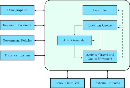
My research is a small piece of a larger research effort: trying to build integrated land use / transportation models that go beyond traditional transportation models. In classic four-stage models for forecasting travel demand, both the transportation network and the shape of the city (land use) is treated as an input to the model, and the travel patterns that would emerge from such a city are estimated. Typically, the goal is to see how changes to the transportation network would impact travel patterns – for example, building a new freeway or subway route. In reality, however, it is not valid to hold land use constant while changing the transportation network – land use reacts to the presence of transportation infrastructure.
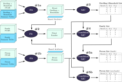
Models of this type have been under development for a long time, and my thesis is part of the ILUTE modelling effort at the University of Toronto. The figure below shows the ILUTE model structure, with land development, household location choice and automobile ownership as integral components of the model, not inputs to the model.
ILUTE model structure
My particular contribution is in the population synthesis part of the model, where I developed a faster and more capable method for synthesizing person, family, household and dwelling agents/objects; and a more robust method for creating the initial relationships between these agents.

  • Presentation: aimed at a fairly general audience (new civil engineering students), but perhaps a little cryptic without the narration.
    [HTML | Powerpoint]
  • Thesis: all of the gory details.
    [HTML | PDF]

IPCC and Land Use

Mike passed me a recent report from the Intergovernmental Panel on Climate Change (IPCC) Working Group III (Mitigation of Climate Change). The IPCC is quite famous for its reports summarising the scientific consensus on climate science, so I was curious to see what the process and results of their follow-up reports looked like. I only read the transport chapter, since it’s the part I understand.
Overall, it’s a decent summary of current understanding of transportation trends, which is difficult to do at an international level with a wide spectrum of urban forms and demographics. The report includes a summary, and working group members vote on each paragraph to establish the level of knowledge and agreement on the report’s conclusions. One paragraph in particular struck me:

Providing public transports systems and their related infrastructure and promoting non-motorised transport can contribute to GHG mitigation. However, local conditions determine how much transport can be shifted to less energy intensive modes. Occupancy rates and primary energy sources of the transport mode further determine the mitigation impact. The energy requirements for urban transport are strongly influenced by the density and spatial structure of the built environment, as well as by location, extent and nature of transport infrastructure. If the share of buses in passenger transport in typical Latin American cities would increase by 5–10%, then CO2 emissions could go down by 4–9% at costs of the order of 60–70 US$/tCO2 (low agreement, limited evidence).
[page 326, emphasis added]

I’m a little shocked that this paragraph garners low agreement and is considered to be backed by limited evidence. (I’ll exclude the final sentence, since I don’t know anything about that particular study.) The paragraph is already weakened by many words indicating uncertainty – “can contribute” … “local conditions” … “could go down” etc. But there isn’t even consensus with the weakened wording. I emphasised the one sentence on density and spatial structure – my personal research interest. Again, I’m astounded that there is still wavering about this subject.
That sentence represents one of the report’s only discussions of urban form. It appears occasionally elsewhere in the chapter, but the framing unfortunately focuses on transportation, and treats land use as fixed – a massive oversight. While there are occasional mentions of the value of “co-ordinating” transportation and land use, these are not quantified and do not make it into the conclusions of the report. There is a separate chapter on housing, but it focuses on building construction and energy consumption, again omitting urban form. As so often in the past, urban structure is forgotten and falls into the cracks between disciplines.
The report sensibly treats the US as a “special case” in the international context, since it’s so low density. (e.g., increasing transit service in many US cities could plausibly increase GHG emissions – if no new riders are attracted but more buses are on the road). But it’s a double-edged sword – it suggests that US cities can continue to follow an auto-dependent path, since the report doesn’t contemplate changing land use.
At the end of the day, though, the main problem is the inconclusiveness of the research – the focus on the exceptional context of the USA has too often limited researchers from observing the clearer trends in other parts of the world. Integrated land use/transport models are still too immature for this type of policy analysis, and international comparison studies remain plagued by data incompatibilities. Finally, the field rarely presents its results in a policy-relevant manner – I have never seen a transportation/land use report that estimated the cost of a policy in terms of US$/tCO2-equivalent. It’s unfortunate – researchers in fields like biofuels are doing a lot of work to estimate greenhouse gas reductions, and their results are immediately relevant to policymakers.

Annotated Readings

Almost all of these readings are old, dating back to my initial forays into understanding transportation. They’re listed in the order I read them, from newest to oldest. Most of the content is just quotations I found interesting, with a few comments. Many of the comments no longer reflect my current thinking; take it with a big grain of salt. If you’re an author of one of these publications and object to the (admittedly extensive) quotations I’ve included here, please let me know.

Jetpacks & garden privacy


I just finished a term paper on “corridors in the polycentric city,” looking at various bodies of literature and their ideas for the urban form in transit corridors linking nodes in a city. Along the way, I read Stephen Marshall’s excellent Streets & Patterns, a well thought-out analysis of road hierarchies and the subtle auto-oriented biases they introduce. Marshall talked at great length about the Buchanan report (Traffic in Towns), a British government report from 1963.
The Buchanan report is an interesting beast. On the one hand, it documented all sorts of ills associated with the automobile in that era: parking everywhere, pedestrian injuries, derelict cars rusting in the middle of the city. On the other hand, the solution it proposed was to give the major street network over to cars entirely, labelling the main network “distributors.” It drew an analogy to a hospital: the rooms of the hospital (neighbourhoods bounded by distributors) are quiet, peaceful places; the corridors of the hospital are filled with food carts, stretchers and people moving everywhere. On the basis of this simplistic analogy, they recommended a similar treatment for cities. Is a city like a hospital, really? Should it be? Those questions went unasked. They also recommended rebuilding many major London streets with a pedestrian superstructure – rebuilding the outdoor pedestrian cafe experience one floor up on a system of walkways above the street. I’m glad that never happened.
The report was well aware of the coming storm: at the time of its writing, the majority of Britons did not yet own cars, but it was clear that the nation had but a few years left. Once the majority owned cars, it was clearly going to be difficult for a democratic government to limit their use.
But in its most entertaining content, the Buchanan report treats some very 1950s sci-fi ideas seriously, like personal jet propulsion:

The motor vehicle has been eroding most of the common amenities of life, but there is still some privacy left in back gardens, verandahs, bedrooms and on roof-tops. All these would be threatened if people could take off vertically at will.

Garden privacy is under threat!

Scholastica

I haven’t actually written much about my school experience here yet, so I thought I’d at least put up a few sentences on my experience with transportation planning here at U of T.
Last term was crazy busy, although in retrospect much of the burden was self-imposed. Since I was starting a new discipline, I was a bit unsure of myself, and worked very hard initially. Once I got a few papers and midterms back and realized that I was doing okay, I relaxed a bit. I took three courses last term:

  • CIV531 (Transport III: Planning): the course crosslisted as both grad and undergrad, and hence taught in an undergrad style: weekly assignments, midterm/final, and no current research content. One half was focused on planning, and the other half on modelling. As it turned out, I already knew most of the planning side, but the modelling was useful to see in depth.
  • CIV1504 (Applied Probability & Statistics): you would think I’d have covered this somewhere in my undergrad, but it wasn’t part of my engineering curriculum. While I’d done a lot of probability, I’d never learned statistical inference or experimental design. The material was by no means difficult, but we covered a lot of ground in a short time, so there was a reasonable amount of work to do.
  • CIV1535 (Transportation and Development): this was a more typical graduate-level course, focused on recent research findings and a broad overview of literature. Many of the assignments were quite fun, including a book review selected from a few of the major classics. The content had a definite modelling flavour to it, but with plenty of context and insight from Prof. Miller.

I was afraid the program might straitjacket into a very narrow set of courses this semester, but my computer science degree thankfully helps me dodge a bit of the methodology requirements. In the end, it’s a very custom-designed course package, very well suited to my needs. This term I’m taking

  • JPG1510 (Recent Debates on Urban Form): a comparison of three current approaches to city design, New Urbanism, Smart Growth and Compact Cities. These schools derive from different fields: architecture, urban planning and environmental/international (UN) perspectives. The readings, professor and seminar format all appeal to me quite a bit – and I’m really interested by this particular debate.
  • JPG1554 (Transportation & Urban Form): another seminar course, focused on the literature on the feedbacks between transport and urban form. While CIV1535 took the modelling viewpoint, this course takes more of a qualitative tack with some support from the limited quantitative analyses that have been performed. I’ve seen some of this literature before, but it’ll be great to look at it again with a fresh eye and stronger statistical skills.
  • CIV1534 (Transport Demand Analysis): a more practical modelling course, apparently quite tough, but a vital and frequently controversial part of practical transportation projects. The demand analysis conducted on many transit projects has been extremely optimistic; I’ll be curious to see if we look at any of that material this term.

Whew. Does anyone care?

Virtual City

The Globe and Mail had a story today about a very cool website for techie urbanists like me: Virtual City. They’ve digitized streetscapes for a ton of Toronto and Montreal cities, and you can use Google Maps to bring up photos of the street. Great idea, and reasonably well implemented. It clearly still needs a bit of work, but I’m definitely going to start using it now! Give it a shot.
I’m not sure what the business plan is. I suppose it’s useful for finding retail: “there was some funky clothing shop on Queen just west of Spadina… what was it called again?”

Sustrans talks galore, and the story of the Cheonggyecheon River

Before
Stacked freeway
After
Urban river

It’s been an eventful two weeks. A ton of urban conferences hit Vancouver: the World Urban Form, the Canadian Institute of Planners Congress, and Planners4Tomorrow.
Enrique Peñalosa gave an inspiring talk about his time as the mayor of Bogotá, Colombia. In a city where less than 20% own a car, why was so much downtown space devoted to automobile movement and parking? He helped institute policies enforcing sidewalk parking bans and limiting automobile access to the downtown. He rejected a Japanese consortium’s $5 billion freeway plans, and instead built a Bus Rapid Transit system similar to the one in Curitiba, Brazil. He built major bikeways, and the city has seen cycling mode share go from 0% to 6% in under ten years. Once people feel safe biking, they’ll do it.
The idea that banning cars can be democratic is interesting, but not very relevant in a Canadian context. In fact, the opposite argument could be posed: non-auto ridership is under 20% in most cities. However, in Bogota the issue was not that car drivers were in the minority, but that they consumed a disproportionate amount of public space and resources. Transit riders in Canada may be in the minority, but they save public money and space. I did read a British report from the 1960s (Traffic in Towns) that anticipated the problems when car drivers reach a majority of the population. British planners could see what had happened in the USA when car ownership passed that threshold. They were rightly concerned about the political difficulty of slowing motorisation once car owners were in the majority. But they didn’t find any way to stop it.
Peter Newman and Jeff Kenworthy were in town last week, and they gave independent talks on the same day. They’re famous for sparking a debate on the relationship between city density and fuel use per capita. After studying several North American, European, Australian and a few Asian cities, they found that there was an inverse relationship between fuel-use-per-capita and urban density. This sounds uncontroversial to the lay person – if things are closer, people need less gas to get around, or they can walk or use transit. However, it sparked a massive debate in the planning world. I’m mostly in their camp, although I’m still skeptical about some of the policy conclusions they’ve drawn. See some of my notes if you’re interested.
Both of them highlighted one fascinating story: the Cheonggyecheon River in Seoul, Korea. The photos on the right show the situation “before” (2003) and “after” its recent reconstruction in 2005. You see that correctly: twelve lanes of traffic (eight below, and four above) were replaced by four lanes, and the river that had been buried beneath in the 1940s was “daylighted” once again. Bridges across the river were rebuilt, changing the barrier expressway into a regular road. Cheap? No, it came with a price tag near US$900 million, although it’s expected to attract about US$12 billion in investment in the surrounding area. Still, a beautiful way to remake a city. Imagine a similar project on the Gardiner Expressway in Toronto, allowing the city to reach its neglected and disconnected waterfront…