A great link from vyaroshevich (via Price Tags and Thrilling Wonder). The flickr photo below shows a horrific left-turn in Russia. The route starts from the left (lower line)… and just follow the arrows from there. If I was on the road, I’m sure it would soon seem fairly natural, actually… we’re very well-trained in the mysterious ways of cloverleaf interchange.
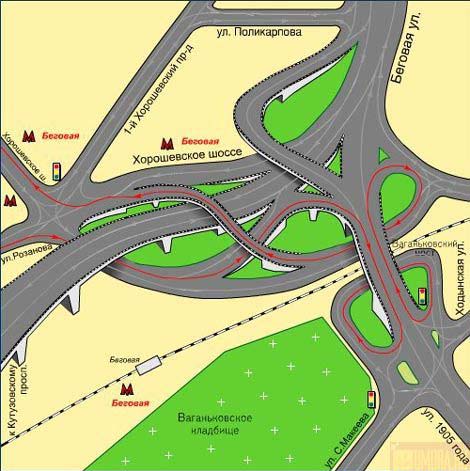
Also check out the Moscow people watching post.
Scholastica
I haven’t actually written much about my school experience here yet, so I thought I’d at least put up a few sentences on my experience with transportation planning here at U of T.
Last term was crazy busy, although in retrospect much of the burden was self-imposed. Since I was starting a new discipline, I was a bit unsure of myself, and worked very hard initially. Once I got a few papers and midterms back and realized that I was doing okay, I relaxed a bit. I took three courses last term:
- CIV531 (Transport III: Planning): the course crosslisted as both grad and undergrad, and hence taught in an undergrad style: weekly assignments, midterm/final, and no current research content. One half was focused on planning, and the other half on modelling. As it turned out, I already knew most of the planning side, but the modelling was useful to see in depth.
- CIV1504 (Applied Probability & Statistics): you would think I’d have covered this somewhere in my undergrad, but it wasn’t part of my engineering curriculum. While I’d done a lot of probability, I’d never learned statistical inference or experimental design. The material was by no means difficult, but we covered a lot of ground in a short time, so there was a reasonable amount of work to do.
- CIV1535 (Transportation and Development): this was a more typical graduate-level course, focused on recent research findings and a broad overview of literature. Many of the assignments were quite fun, including a book review selected from a few of the major classics. The content had a definite modelling flavour to it, but with plenty of context and insight from Prof. Miller.
I was afraid the program might straitjacket into a very narrow set of courses this semester, but my computer science degree thankfully helps me dodge a bit of the methodology requirements. In the end, it’s a very custom-designed course package, very well suited to my needs. This term I’m taking
- JPG1510 (Recent Debates on Urban Form): a comparison of three current approaches to city design, New Urbanism, Smart Growth and Compact Cities. These schools derive from different fields: architecture, urban planning and environmental/international (UN) perspectives. The readings, professor and seminar format all appeal to me quite a bit – and I’m really interested by this particular debate.
- JPG1554 (Transportation & Urban Form): another seminar course, focused on the literature on the feedbacks between transport and urban form. While CIV1535 took the modelling viewpoint, this course takes more of a qualitative tack with some support from the limited quantitative analyses that have been performed. I’ve seen some of this literature before, but it’ll be great to look at it again with a fresh eye and stronger statistical skills.
- CIV1534 (Transport Demand Analysis): a more practical modelling course, apparently quite tough, but a vital and frequently controversial part of practical transportation projects. The demand analysis conducted on many transit projects has been extremely optimistic; I’ll be curious to see if we look at any of that material this term.
Whew. Does anyone care?
Virtual City
The Globe and Mail had a story today about a very cool website for techie urbanists like me: Virtual City. They’ve digitized streetscapes for a ton of Toronto and Montreal cities, and you can use Google Maps to bring up photos of the street. Great idea, and reasonably well implemented. It clearly still needs a bit of work, but I’m definitely going to start using it now! Give it a shot.
I’m not sure what the business plan is. I suppose it’s useful for finding retail: “there was some funky clothing shop on Queen just west of Spadina… what was it called again?”
Narscissism
No, that’s not a typo. I spent the last three days at the North American Regional Science Conference (NARSC), here in Toronto at the Royal York hotel. It’s probably not the type of conference I would normally attend – the focus is more on regional economic models than transportation or land use – but it was in town, cheap, and a good chance to get a feel for conferences in my new field of study.
My points of reference are the last two academic conferences I attended: SIGGRAPH and Eurographics. Computer science tends to treat conferences as a discussion of published results after peer review is complete. NARSC was more conventional, serving more as a place to discuss works in progress prior to submission to a journal. The cultural differences were large: while the computer science conferences (especially Eurographics) are dominated by under-35s, there were few under 40 here. Supervisors often presented their students’ papers, instead of the other way around. The dress code was a little stiffer than SIGGRAPH: souvenir T-shirts from past conferences would not go over well; suits and ties were the order of the day.
Anyways, it was interesting. I don’t really buy into some of the regional economic models that are used, but it was refreshing to see some people using spatial statistics rigorously, at a level far beyond many papers from urban planning journals. One of these days, I should learn something about these hedonic methods I keep hearing about in econometrics.
I also tried to get some less-techie sessions to balance my mathed-out semester. There was one session discussing the impact of Jane Jacobs, particulary her influence on economists. One presenter argued that Jacobs was really very conservative, an argument that I didn’t entirely buy. He argued correctly that Jacobs was often opposed to government intervention in markets, and large public sector projects in general, often arguing for privatization. This puts her in the same camp as the conservatives, but for very different reasons. Unlike the libertarians, Jacobs did not aim for freedom from government as an end in itself. Instead, her conservative side was rooted in a love of diversity, choice and competition. That’s a type of conservatism that I can definitely buy into. I don’t love or hate government for its own sake, but I do really like choice and diversity, provided that equality, social justice and opportunity also flourish. My objection to the libertarian approach is largely that unregulated markets often don’t lead to diversity, choice and competition, but instead lead to stifling monopolies or oligopolies. And libertarians are frequently content to ignore issues of equality of opportunity and social justice.
Dutch bike culture
On the VACC listserv today, Gregg Sayer posted a great article on bike culture in the Netherlands. Small-wheel bikes are clearly the thing of the future out there – he’s got some great pictures of cargo bikes. Check it out, and see some photos of an eight-man cycling beer machine.
Gregg Sayer’s blog.
Sustrans talks galore, and the story of the Cheonggyecheon River
Before
After

After

It’s been an eventful two weeks. A ton of urban conferences hit Vancouver: the World Urban Form, the Canadian Institute of Planners Congress, and Planners4Tomorrow.
Enrique Peñalosa gave an inspiring talk about his time as the mayor of Bogotá, Colombia. In a city where less than 20% own a car, why was so much downtown space devoted to automobile movement and parking? He helped institute policies enforcing sidewalk parking bans and limiting automobile access to the downtown. He rejected a Japanese consortium’s $5 billion freeway plans, and instead built a Bus Rapid Transit system similar to the one in Curitiba, Brazil. He built major bikeways, and the city has seen cycling mode share go from 0% to 6% in under ten years. Once people feel safe biking, they’ll do it.
The idea that banning cars can be democratic is interesting, but not very relevant in a Canadian context. In fact, the opposite argument could be posed: non-auto ridership is under 20% in most cities. However, in Bogota the issue was not that car drivers were in the minority, but that they consumed a disproportionate amount of public space and resources. Transit riders in Canada may be in the minority, but they save public money and space. I did read a British report from the 1960s (Traffic in Towns) that anticipated the problems when car drivers reach a majority of the population. British planners could see what had happened in the USA when car ownership passed that threshold. They were rightly concerned about the political difficulty of slowing motorisation once car owners were in the majority. But they didn’t find any way to stop it.
Peter Newman and Jeff Kenworthy were in town last week, and they gave independent talks on the same day. They’re famous for sparking a debate on the relationship between city density and fuel use per capita. After studying several North American, European, Australian and a few Asian cities, they found that there was an inverse relationship between fuel-use-per-capita and urban density. This sounds uncontroversial to the lay person – if things are closer, people need less gas to get around, or they can walk or use transit. However, it sparked a massive debate in the planning world. I’m mostly in their camp, although I’m still skeptical about some of the policy conclusions they’ve drawn. See some of my notes if you’re interested.
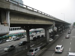
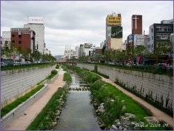
Both of them highlighted one fascinating story: the Cheonggyecheon River in Seoul, Korea. The photos on the right show the situation “before” (2003) and “after” its recent reconstruction in 2005. You see that correctly: twelve lanes of traffic (eight below, and four above) were replaced by four lanes, and the river that had been buried beneath in the 1940s was “daylighted” once again. Bridges across the river were rebuilt, changing the barrier expressway into a regular road. Cheap? No, it came with a price tag near US$900 million, although it’s expected to attract about US$12 billion in investment in the surrounding area. Still, a beautiful way to remake a city. Imagine a similar project on the Gardiner Expressway in Toronto, allowing the city to reach its neglected and disconnected waterfront…
GO Transit
![]()
I’ve been reading Steve Munro‘s blog lately, as he discusses the nitty-gritty details of transit planning in Toronto. He brought up an interesting point regarding the extension of the Spadina subway line to York University: there’s already a GO transit line that goes direct from York University to downtown, and GO is a better way of feeding people into the downtown than the subway line. (The Yonge line is already at capacity now.)
So what about GO? I’ve only used it once or twice, and I really didn’t know much about it. I didn’t even have a picture of the network. So, I added the routes to my Toronto transit map. It was an interesting exercise – I’d never thought of Dundas West or Leslie subway stations as interchanges, but they are. You get a different view of the connectivity of the city this way – Agincourt is surprisingly close to downtown (a 27 minutes ride), the Danforth station near my parents’ house is only 11 minutes from downtown, and York University is only 22 minutes from downtown. Living in downtown without a car, there are routes to take you a huge distance from Toronto: Bradford, Milton, Hamilton, and Oshawa are all in reach. If you combined GO with a bicycle, you could get to Lake Simcoe or tour the rural areas around Toronto.
The problem, however, lies in the frequency and the hours of operation. Most of those trains only serve one-way peak hour travel, so you can’t use them for a daytrip from downtown to the hinterlands. And they run so infrequently that you would rarely choose them as an alternative to the subway. As Steve Munro suggests, we really need upgraded service on the GO lines. I’d love to see a service like Lausanne offered, with trains in every direction at reasonable frequencies.
I think it’s interesting that GO is so absent from the lives of Toronto residents. As a local, I was completely oblivious to that network – mostly, I guess, because it was nearly useless to me with its present service levels. It doesn’t even show up on TTC maps, which further marginalizes it. My only awareness of GO was where the tracks disrupted my bike ride, like the dip under the tracks on Woodbine. And yet, it could be a valuable part of carfree life in the city.
Cyclist falls off bridge

This past weekend, I rode my bike down through Surrey, North Delta and Annacis Island. It was the first time I’d taken my bike across the Alex Fraser bridge, and it had a few scary moments: a narrow sidewalk, and a low railing, plus three danger spots. The freeway signposts block the path at two points, narrowing it to essentially the width of my handlebars. At another point (shown in the photo from behind and front), the path makes a sudden sharp jog. Two of those three danger zones were in downhill sections, where cyclists could easily be riding quite fast. When I see scary bridges like this or the Second Narrows bridge, I always think about what would happen if I made a mistake. Could I tumble over the railing and fall right off the bridge? Optimistically, I assumed the engineers considered these things when they design the bridges.
Apparently not. In the paper yesterday, I saw a report from Mississauga. “From witness reports it is believed the handlebars of Sacawa’s bike may have become caught between two of the bridge’s metal posts. The impact caused him to lurch forward and tumble over the side of the bridge.” (CTV) “The railing he went over stands a bit more than one metre high, roughly the height of a tall man’s waist.” (Globe and Mail). He fell 150 feet to his death. Scary, scary stuff.
Bad bicycle routes
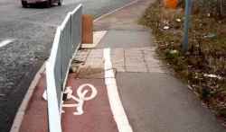
The BBC is running an entertaining photo series on bad bicycle routes, and they have a link to some other photos too.
Apparently, they’re considering amending their highway act to require cyclists to use a bike lane if present. This is an effort by cyclists there to stop that, since so many bike lanes are badly designed or unusable. The problems are wide-ranging: obstacles in the path, too narrow, parking allowed on the bike lane, no lane sweeping, and so on.
Does it matter, when you can just break the law? Well, yes. If a driver hits a cyclist when the cyclist is breaking the law (no matter how stupid the law), the cyclist will often have a hard time getting compensation. In some European countries, the law sides with cyclists, and the responsibility almost always falls on the driver, but not in most Anglo-Saxon countries.
Toronto Transit Map
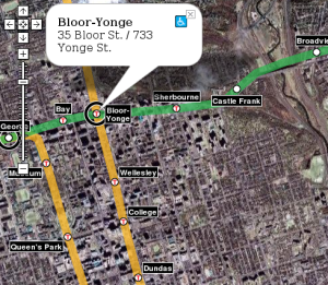
Last August, I put together a transit map for Vancouver using the new Google Maps API. I recently went through and updated all the code, switching it over to XML for the geographic data. Using that backend, I’ve now put together a Toronto transit map. So far, I’ve only got the TTC on there – GO bus and train routes would also be valuable, of course.
It was an interesting exercise to put together. I now understand why I never use the northern part of the Spadina line: north of St. Clair West, it runs directly under the Allen Expressway, which kills the life around those stations. When transit and freeways compete, freeways usually win. I also now see the folly of the Sheppard line: I think it’s too close to the 401 to compete. Additionally, since it’s north of the 401, it’ll never be able to capture much ridership from anyone living south of the 16-lane freeway, even though there’s probably more potential for dense development on the south side, closer to downtown. It’s interesting to compare the station density in Toronto and Vancouver: the Toronto stops are much, much closer together than the Vancouver stops. The new Sheppard line is similar to Vancouver station spacing, though.
And incidentally, I’ve also updated the Vancouver transit map to include the two routes that’ll be finished in 2010: the Canada Line (a.k.a. RAV / Richmond-Airport-Vancouver) that will replace the 98 B-Line and the Evergreen Line that will replace the 97 B-Line.
I’d like to allow others to add a transit layer to maps on their web pages. When I last used Housing Maps to view CraigsList listings on google maps, I found myself desperately wanting a transit overlay. I think it’d be possible to write a Mozilla addon button that just added a transit map to whatever webpage you’re viewing… I’ve just got to figure out how to do it.